We have had a few trips out with our motorhome (aka Vannie) over the last few months so I thought I would share some of our adventures with you.
In April we spent a few days at Melrose in the Scottish Borders. We stayed at Gibson Park Caravan Site, which is right near the centre of the town, just across the road from Melrose Rugby Club.
Melrose is a lovely little town on the banks of the River Tweed and there is plenty to see there, including the famous Melrose Abbey:
 |
| Melrose Abbey over the wall |
 |
| Melrose Abbey and Graveyard |
 |
| Melrose Abbey and the Eildon Hills |
The abbey was originally founded as part of a Cistercian monastery in 1136 on the request of King David 1 of Scotland. It has been enhanced, burnt down, rebuilt, attacked, rebuilt, modified, etc. over the years and is now preserved in its current state by Historic Scotland. It also holds a lead casket which is reputed to contain the embalmed heart of Robert the Bruce.
The Eildon Hills which sit behind Melrose have three peaks (although only two are shown in the picture above) and this was reflected in the name of the Roman Fort 'Trimontium' that existed here back in the 1st century.
There are many good walks in and around Melrose, ranging from leisurely riverside strolls to strenuous hikes up the Eildons. We started off with a little stroll along the side of the River Tweed:
 |
| River Tweed at Melrose |
 |
| Chain Bridge across the Tweed |
 |
| Chain Bridge and Eildon Hills |
 |
| Across the Chain Bridge to Gattonside |
The Chain Bridge was opened in 1846 and is a pedestrian bridge which links Melrose to Gattonside. It was originally a toll bridge and I particularly liked the message conveyed by these notices on the tower of the bridge:
 |
| Chain Bridge Notices |
No messing about on this bridge then; the views from the bridge were quite good though:
 |
| River Tweed upstream of Chain Bridge |
 |
| River Tweed downstream of Chain Bridge |
Our next foray involved a walk along the old railway line from Melrose to the nearby village of Newstead:
 |
| Melrose from Newstead railway path |
Newstead is a quaint little village with a mixture of old and new dwellings; I particularly liked this old building and its intriguing road sign:
 |
| Fame at last |
The 'Eddy' refers to an area of low-lying land beside the River Tweed which floods when the river level is high. Intrigued we had a walk down Eddy Road to the riverside:
 |
| Down Eddy Road |
 |
| Old Swings down Eddy Road |
 |
| Bend in the River Tweed |
On the opposite side of the river from where we were standing there was an exposed bank which contained many holes , and there were dozens of Sand Martins checking these holes for potential nest sites. Here is a slow motion video showing some Sand Martins skimming the top of the river feeding on insects................... had it been at full speed you would have struggled to see these fast flying, aerobatic birds:
After watching the martins for a while we headed back to Melrose along the riverside path, enjoying the views on the way:
 |
| Tweedside Hawthorn |
 |
| Gorse-covered Hillside |
 |
| Mallard on a wall! |
 |
| Abbey, Eildons and Rugby.......it must be Melrose. |
The next day the sun was shining, although there was still a nip in the air with a cool wind blowing from the north. This time we decided to take a walk along the river in the opposite direction from Newstead, heading towards Tweedbank:
 |
| Gattonside across the Tweed |
 |
| Riverside walk to Tweedbank |
Alongside the river you really felt the cold wind even though the sun was shining, hence the need for winter clothing:
 |
| Moira enjoying the riverside walk |
 |
| Lowood Bridge |
Lowood Bridge joins Tweedbank to Gattonside and this is where we left the riverside walk and headed to the new Tweedbank Station:
 |
| Plaque at Tweedbank Station |
This station is the end of the line on the new Borders Railway, opened in 2015.
After a bite of lunch in Herges (adventures of Tintin) we headed back to Melrose, this time taking the riverside walk along the opposite bank at Gattonside:
 |
| Eildons from Gattonside |
 |
| Fishing the Tweed at Gattonside |
We crossed the Chain Bridge and headed back to the caravan site. We headed home the next day having had an enjoyable few days in Melrose.
A few weeks later we took a trip to the Southern Highlands and stayed in the campsite at Maragowan, just on the outskirts of the town of Killin. This was a lovely campsite in an area with fantastic scenery, although the weather wasn't too great for the fist day or two:
 |
| Maragowan Caravan Park and the River Lochay |
 |
| River Lochay with the Tarmachan Ridge in the background |
This was the first outing with the new awning we had bought for Vannie; it was like having a conservatory attached to your motorhome:
 |
| Vannie with new awning |
 |
| Me outside awning |
 |
| Moira inside awning |
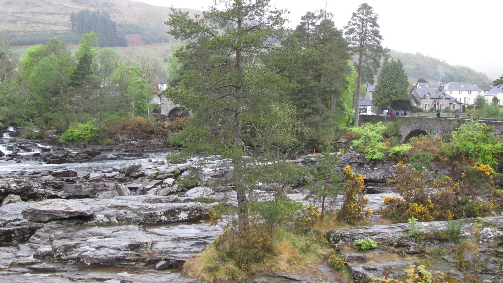
Although the weather wasn't great the first couple of days that did not stop us getting out and about. First visit was a walk around the town of Killin, including a visit to the town's famous Falls of Dochart:
 |
| Falls of Dochart and Watermill |
 |
| Bridge over the River Dochart |
The best place to take photos of the Falls is from the Dochart Bridge, unfortunately this is a narrow bridge and can be busy with traffic, so not an ideal place to stand and take photos. I did manage to get one without being run over:
 |
| Falls of Dochart from Bridge |
On the other side of the bridge from the falls the river splits into two streams, and between these two streams lies an island, on which lies the clan McNab ancestral burial grounds:
 |
| Clan McNab Burial Grounds |
Of course this is all detailed in the interpretation board near the falls, if you choose to read it:
 |
| Killin Heritage Trail Interpretation Board |
We also visited the art gallery/craft centre/antique shop/junk shop in the watermill whilst we were there............ strange place??
For our next walk we went along Glen Lochay road, a little back road on the north side of Killin. The aim was to reach Moirlanich Longhouse, a good example of a 'cruck frame building with a hanging lum' ........... a typical Highland Longhouse from the 19th century. It was a day of changeable weather with some sun and some heavy showers, however there was plenty to see on the way to the longhouse:
 |
| Road to Glen Lochay |
 |
| Moira in the rain |
 |
| Wooded copse with some ruins |
 |
| Beautiful Roadside Birch |
Unfortunately when we reached the longhouse we found out that it was only open on certain days and this was not one of them. So we contended ourselves with viewing it from the outside:
 |
| Moirlanich Longhouse |
On the way back we came across a strange creature:
 |
| A Tub o' Lamb |
And in another field we saw a Greater-spotted Woodpecker playing hide-and-seek behind a grassy knoll:
I guess there must have been some rotten log behind the grassy knoll which it was pecking to find insects and grubs. The background music was kindly provided by workman with a blaring radio at a nearby farm cottage.
The following day the weather had picked up a bit and the sun dared to shine. We took the opportunity of fine weather to go for a walk from Killin, down the old railway line and head towards Loch Tay:
 |
| Old Railway Bridge |
As we reached this old railway bridge, which crosses over the River Lochay, we were joined by a couple of Pied Wagtails:
Crossing over the bridge we turned right and headed along the side of the River Lochay towards Loch Tay:
 |
| On the Banks of River Lochay |
A bit further on the River Lochay joins the River Dochart, before entering Loch Tay:
 |
| Where River Lochay joins River Dochart |
 |
| Moira on the path to Loch Tay |
Shortly afterwards we reached the point where the rivers join the western end of Loch Tay:
 |
| Loch Tay with Ben Lawers in the background |
Although Ben Lawers at 1,214m (just under 4,000ft) is the highest mountain in the southern part of the Highlands, I thought looking back to Killin that the view of Sron a' Chlachain (at 520m) was just as impressive:
 |
| Sron a' Chlachain behind Killin |
The view of the Tarmachan Ridge wasn't too bad either:
 |
| Tarmachan Ridge |
The next photo may look like Moira is on a golf course but it was just a path alongside Loch Tay:
 |
| Moira with the Tarmachan Ridge in the background |
As well as all these lovely hills there were some fantastic views down Loch Tay:
 |
| Loch Tay Panorama |
 |
| Reedbeds at Loch Tay |
The shoreline of Loch Tay had a few birds on it, mainly Oystercatchers, Pied Wagtails and a variety of gulls. One type of gull (which despite its name is not very common) was nesting nearby on a raised tuft of grass:
That was a Common Gull of course, a sort of miniature version of the more common Herring Gull.
After a very enjoyable visit to the shores of Loch Tay we headed back to the caravan park using Pier Road. This turned out to be a pleasant return route through a wooded area with road-sides lined by Bluebells:
 |
| Bluebells along Pier Road, Killin |
 |
| Bluebells and Poppies |
Further along the road there was a track that lead to the ruins of Finlarig Castle:
 |
| Turn right for Finlarig |
 |
| Ruins of Finlarig Castle |
Just before the end of Pier Road we saw these cute lambs playing in a field:
 |
| Ewe Looking At Me? |
I bet you are thinking "these puns are Killin me"................sorry about that!
We really enjoyed our time at Killin and Maragowan caravan park was a great site, well worth a visit.
We are now looking forward to some summertime trips with Vannie
Take Care
Teddyedward