Sunday, 19 September 2021

Dingwall and the Great Railway Journey

 Back in the middle of July we had a trip out in the motorhome to spend a few days at Dingwall Camping & Caravanning Site, a place we hadn't visited before. After getting parked up at our pitch and sorting out the awning and all the other gubbins that are associated with motorhoming, we went for a walk to explore the local area.

We started with a walk along the side of the River Peffery, which is a smallish tidal river that leads in to the Cromarty Firth:

Path alongside the River Peffery

Beyond the River Peffery to the Cromarty Firth

After a few hundred yards we came to a little wooden bridge that allowed us to cross the river on to the shores of the Cromarty Firth. The tide was out so the river banks were very muddy and the water in the Cromarty Firth was miles away:

Crossing the River Peffery

Moira on the Shores of The Cromarty Firth

If you look very carefully at the last photo you will see the Cromarty Bridge in the far distance.

We headed back over the wooden bridge and continued our walk down river until we came to the point where the river joined the estuary (or firth):

River Peffery and Muddy Estuary

A little further along we reached a headland with benches, trees, sculptures and manicured grass. This provided us with views of the Cromarty Firth and of the River Conon, which also joins the firth at this point:

Towards Cromarty Firth

Headland where River Conon joins Cromarty Firth

River Conon

These gulls walking in the estuary might give you an idea how muddy it was:


We headed back to the caravan park along Ferry Road; which took us past the football ground of Ross County FC, which was a beer can's throw away from the the site:

The Home of Ross County FC

Camping and Caravanning Site at Dingwall

It was a pleasant little walk and set us up for our tasty barbeque that night:

Burger King?

mmmmmm!

After a hearty meal and a few beers we retired for the night.

Next morning we were up bright and early as we had a train to catch. We had booked return tickets from Dingwall to Kyle of Lochalsh and were looking forward to one of the great railway journeys in Scotland hoping for some stunning views.

The weather was a bit overcast, but it was dry so we picked our seats on the train and sat back for a relaxing two hours train journey. The only blot on a perfect trip was that the train windows were a bit dirty in places, not conducive to good photography, so I apologise in advance for quality of my images.

The train heads North for a few hundred yards (passing right by the campsite) before veering left and heading due West to the opposite coast of Scotland. The first part of the journey took us mostly through wooded areas with very little photo opportunities until we reached Garve:

Loch Garve

Garve Station

A little further on the track ran alongside the River Bran as it wound it's way east from the hills above Achnasheen to join the River Conon via Loch Luichart, and ultimately reach the Cromarty Firth:

Running alongside the River Bran

River Bran and distant hills

We then passed Loch a'Chuilinn, which is fed by the waters of the River Bran:

Loch a'Chuilinn

Another part of Loch a'Chuillin

We were enjoying our rail journey, despite the need to wear masks (no it's not the great train robbers!)

Selfie Time

Others were less concerned about the scenery, probably a regular commute to them:

Passing Loch Achanalt


Further along the track we stopped at Achnasheen Station, where it looked like they had been carrying out some ballast work on the line:


Achnasheen Station

Digger on Rails, Achnasheen

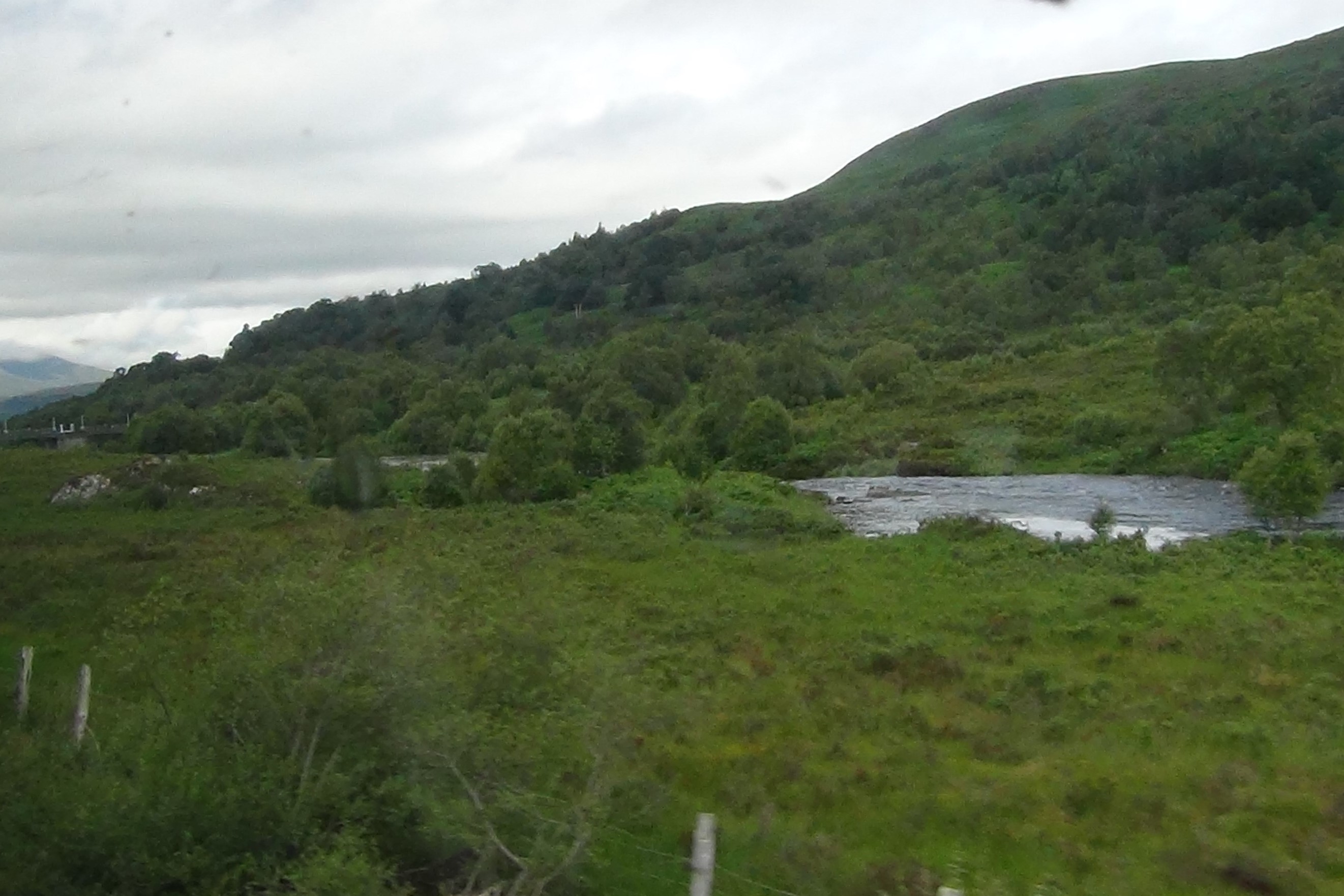
After Achnasheen we skirted alongside the A890 heading towards the high mountains of Strathcarron and Torridon:

Running alongside the A890

Heading towards the High Mountains

We still had the River Bran running alongside us as we passed by Loch Gowan:

River Bran flowing from Loch Gowan

Loch Gowan

River Bran and the A890

We were now about halfway through our journey, and also halfway across the country.............. the River Bran was no longer flowing eastward alongside us.................. it would soon be the River Carron flowing westward................ were at the watershed!

Approaching Glen Carron

Loch Scaven

Loch Scaven marked the start of Glen Carron, an area peppered with shooting estates:

Glenluig Estate

Glencarron Estate

Achnashellach Station was one of the few signs of human habitation since Achnasheen:

Achnashellach Station in Glen Carron

Thereafter we started to see a few other houses, some even had Red Deer Stags in their garden (I don't think it was a pet):

Nice House near Achnashellach

Red Deer Stag in Garden (bottom left)

As we passed another pretty cottage we could see that the high hills of Strathcarron were drawing ever closer:

Pretty Little Cottage

The High Hills of Strathcarron

Before we knew it we were right amongst the hills, enjoying fantastic views of the rugged mountain peaks:

The Hills around Sgorr Ruadh

Sgorr Ruadh (aka Red Peak)

Fuar Tholl (aka Wellington's Nose)

Strathcarron Hills

Once passed the high hills we pulled into Strathcarron Station:

View from Strathcarron Station

Strathcarron Station

After Strathcarron station the valley opens up and you can see the head of Loch Carron in front of you:

Head of Loch Carron

Soon you are alongside Loch Carron and enjoying views over to the other shore:

Skirting Alongside Loch Carron

The Shores of Loch Carron

The Town of Lochcarron on the far shore

Lochcarron on Loch Carron

You may already know but Loch Carron is a sea loch, and further along the track that was evident; as the track followed along the shores of the loch, each bay we passed started to look more tidal:

The Shores of Loch Carron

A Tidal Bay on Loch Carron

You could also see the distant hills beyond the far shores of the loch:

The hills beyond the far shores

There were also some cottages on the shoreline with fantastic views:

Nice Cottage on the Shores of Loch Carron

Nice Cottage, Nice Views

A little further along the track we reached Stromeferry, which is the narrowest point of Loch Carron; hence why there was a ferry and a railway station:

Stromeferry Station

View from Stromeferry Station

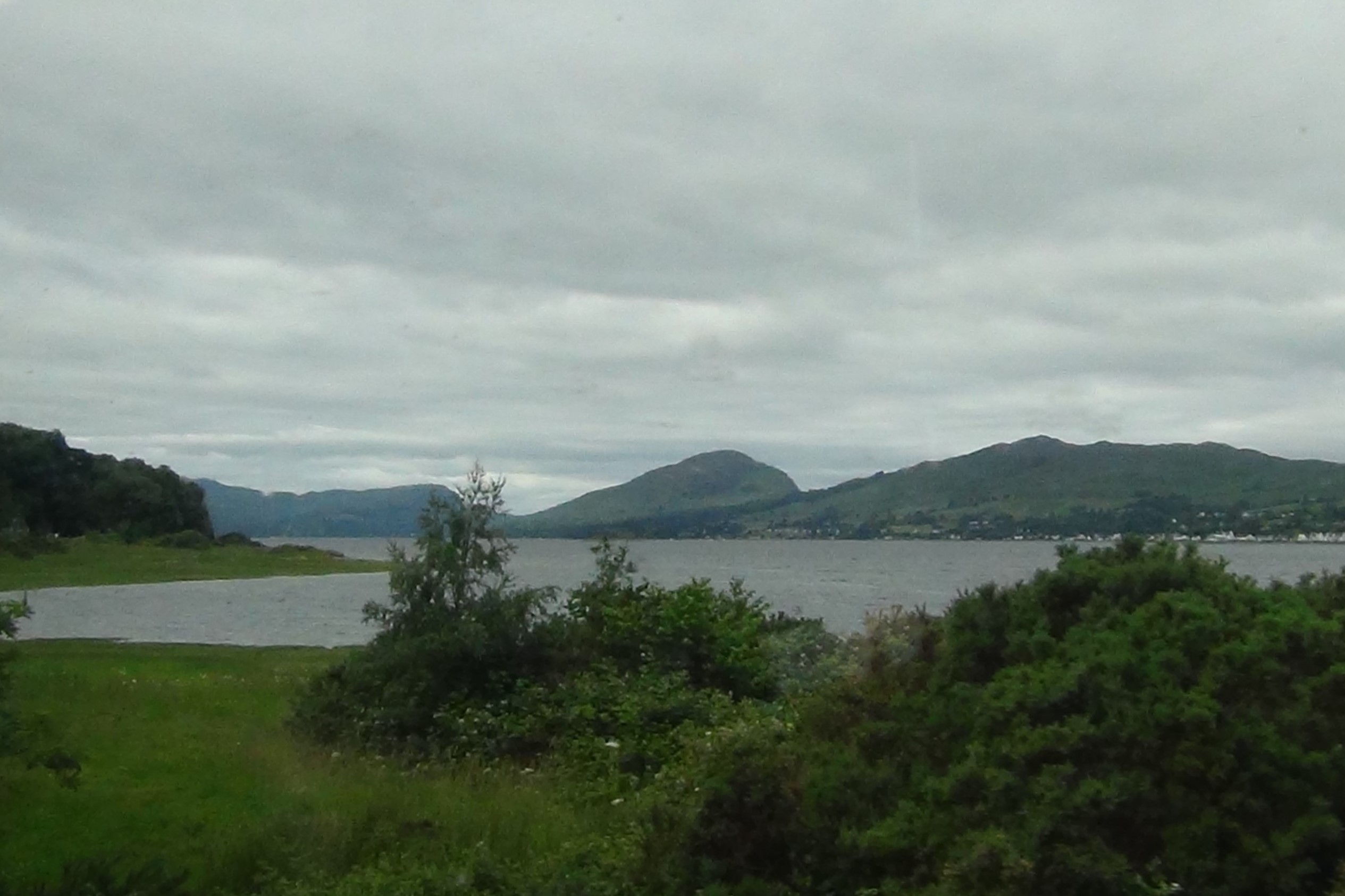
Beyond Stromeferry the loch widens and joins Loch Kishorn to form an estuary that feeds in to the Inner Sound of Skye. Here we saw a lovely house with fantastic views towards Isles of Skye:

Beautiful House with Fantastic Views

Towards the Isles of Skye

Our last stop before turning south to head in to Kyle of Lochalsh was Plockton and this was looming closer as we headed along the shoreline:

Island in the bay at Plockton

Heading towards Plockton

Plockton

At the southern end of Plockton we stopped at the railway station, where quite a few people got off and some got on board the train:

Plockton Railway Station

Pretty Station Building at Plockton

After Plockton we could clearly see that the views were much more 'coastal' and that the Isle of Skye was right in front of us:

Coastal Views

Isles of Skye on the Horizon

Over the sea to Skye

Shortly after this we trundled in to Kyle of Lochalsh Station, some two hours after we left Dingwall:

The Station at Kyle

Kyle of Lochalsh Station with Skye in the background

It was amazing how close we were to Skye when we stopped at the station, but then the ferry used to run between these two points before the bridge was built.

The first thing we did on arrival was to go looking for a cup of tea and a snack, which wasn't easy as many places were closed (or hadn't reopened after Covid). We bumped into another couple (George and Linda from Perth) who were also trying to find somewhere to eat. Coincidently they were also at the same caravan park at Dingwall and had travelled through on the train for the day out. We finally found a cafe called The Lighthouse (which was in the Lochalsh Christain Fellowship building) and we all  enjoyed a nice cup of tea and a scone.

We then had a look around the few gift shops in Kyle, whilst George and Linda decided to have a walk to the Skye Bridge. From the viewpoint down by lifeboat station we could see the Skye Bridge and didn't fancy walking to it:

Skye Bridge from Kyle Lifeboat Station

Moira and the Skye Bridge

We also had some good views of the Isle of Skye itself, and the nearest town on it Kyleakin:

Isle of Skye from Kyle of Lochalsh

Kyleakin on Isle of Skye

We had a bit of a wander around the town (which didn't take long) then we headed back towards the station to wait for the next train to arrive. At the station I took a few photos of the lovely scenery and Moira took a photo of the not-so-lovely me:

Little Boat heading towards Loch Alsh

A blot on the Landscape

Little Boat still chugging along

Although the sun had decided to shine (now and again) it was still a bit misty looking over to Skye and the little islands at the start of Loch Alsh:

Misty Skye

Little Islands at entrance to Loch Alsh

Looking down Loch Alsh

You also got quite good views of the Skye Bridge from the bottom of the railway platform:

Skye Bridge from Kyle Station

A little while later the train arrived and we got on board; taking seats on the opposite side so we could get alternative views on our return journey. However with less people on the train this time we could easy see both sides of the track without disturbing anyone else.

I won't bore you with more photos of the train journey back to Dingwall, but I will share this little video which gives you a taste of the enjoyable ride as the train weaves it way along the coast and the shores of Loch Carron:


The next day we had a leisurely morning with a stroll around the town of Dingwall, popping in to a few shops to browse and buy some gifts. In the afternoon we took a walk along the banks of the Peffery again; but this time it was like a different place, the tide was high and the muddy old river and estuary had gone!

River Peffery at High Tide

Kayaks on River Peffery

Yes it was even deep enough to support a couple of Kayaks:

Kayakers enjoying the River Peffery

Not sure they want to go too far up the river, might be a bit muddy coming back down.

From the footbridge across the river we could see that the point where the river joins the Cromarty Firth was completely different, more like the harbour it use to be hundreds of years ago:

Moira on the Footbridge

View of Estuary from Footbridge


The Cromarty Firth was now full of water and looked more like a vast estuary than some extensive mudflats:

Cromarty Firth from other side of Footbridge

Cromarty Firth from Headland

Shores of Cromarty Firth

On the other side of the headland we could see that the River Conon had also expanded to become quite a wide river:

Eddie beside the River Conon

The River Conon

We walked past the houses on Ferry Road down towards where the ferry to Alcaig (on the opposite shore of the Conon) use to run from. On our route we passed a field that had a few Hares in it, but they were too quick for me to get any photo of them:

Field with Hares in it (honest)

There wasn't much evidence left of the Ferry Point when we got there, but we were about a hundred years too late:

Point where ferry used to cross the River Conon to Alcaig

Nice view all the same.

We headed back along the track to Ferry Road, still no Hares in the field but we did get a Rabbit:

Rabbit in the Hare's field

Never mind it was a nice walk anyway.

On reflection we had a really enjoyable few days at Dingwall Caravan Park and we would certainly go back in the future.

Take care of yourselves,

Teddyedward


Friday, 30 July 2021

Loch Doon in June

 In my last blog I alluded to the fact that I was heading back down to Ayrshire to carry out a bird survey in June. This was my second visit to Loch Doon this year to carry out an Upland Breeding Bird Survey on behalf of the BTO. Normally I would stay at Ayr Caravan Park the night before the survey but on this occasion I thought that I would try the little campsite on the Northwest tip of Loch Doon.

It is quite a basic campsite but had everything I needed for an overnight stay, and I have to say that the views and wildlife were terrific:

View from Loch Doon Caravan and Camping Park

New Vannie parked up for the night

It was a bit of a grey afternoon when I got there but at least it was dry. So I made myself a cup of coffee and settled down to enjoy the views out the windows. Out the front window I could see the loch and the surrounding hills, out the rear I could see a small stand of trees and some rough pasture. it was out this rear window that I got my first view of the local wildlife, starting with a Male Wheatear:


I knew there were Wheatears in the area because I normally see them during my survey, however it was great to see one out my window. My enjoyment didn't end there as another Wheatear, a female this time, popped up to say hello!


Looks like these posts are popular perches for the local Wheatears.

I finished up my coffee and decided to go for a walk, however a cursory glance out the rear window before I left revealed that there was another bird worth looking at.

Ringed Plover on grass behind Vannie

 It was a lovely little wader called a Ringed Plover and it was on the hunt for a tasty morsel in the short grass of the campsite:


It had caught a Cockchafer beetle grub and had quite a fight to devour this wriggly meal, but it managed, then went looking for more. Never tried them, they may be tasty? 

Once the Ringed Plover had flown off I decided it was time to go for that walk and explore the local area. I headed down to the loch-side and took in the views:

Loch Doon and Southern Uplands

Towards Loch Doon Dam

I had crossed over Loch Doon Dam in the motorhome on my way to the campsite so I thought that I would stroll back down towards the dam and see what I could see on the way. There were plenty of birds flitting about, mainly Pipits, Wheatears and Skylarks, with the occasional Sand Martin. On the shoreline and on the water there were some Black-headed Gulls and one or two Common Gulls.

A little further along I spotted a couple of Meadow Pipits lurking in a bush so managed to video them:


I continued along the road until I reached the dam. It may not be the largest or most impressive dam in the world but it served a purpose as part of the Galloway Hydro Electric Scheme:


Loch Doon Dam

It did however have a little cafe nearby, namely the Roundhouse Takeaway (I know, in the middle of nowhere) so I couldn't resist a latte and a muffin!

At the Roundhouse there is also an Osprey Viewing Centre, basically a TV screen showing the view from a camera trained on an Osprey nest on the other side of the loch. Not a lot of action was seen on the nest and the person describing where the nest was located was understandably a bit vague (you don't always want to give out too specific a location if you are unsure who your audience is). 

After my coffee and bun I headed on back towards the campsite. I stopped on my way back as a curious lamb took an interest in me:


Whilst I was waiting for the sheep to move off I thought that I would check the trees on the other side of the loch in case an Osprey was perched on the top of one:

BINGO! ..........It was quite far away and I didn't have my telescope or tripod, but even in this shaky video you can tell it is an Osprey:


I got back to the motorhome in time for tea, once I had made it of course.

After tea I went out for an evening stroll, staying local to the campsite. I passed a little babbling burn on my walk and also noted the abundance of blossom on a Hawthorn bush:

Babbling Burn

Hawthorn in Blossom

I also got some lovely evening views of the loch.

Loch Doon in the evening

It was a Friday evening and the loch-side road was starting to get busy with traffic. People were arriving from all directions to camp on the shores of the loch in their tents, armed with their portable barbeques and a week's supply of beer. I was glad that I had my pitch booked at the campsite, so I headed back. 

I was surprised (and pleased) that it was relatively quiet that night, that may be because it started to rain late on and probably put a damper on some folks enthusiasm. I got a good night's sleep and was up bright and early (before 6am) so that I could make an early start on my survey. After breakfast I got motorhome ready for the road then drove round to the other side of the loch to start my survey.

After parking up in the nearest layby to the survey site I got my kit together and headed out of the motorhome. I had only walked a few yards when this Red Kite took off from nearby trees and flew right over my head:


Once it had gained enough height it headed away over the hills, I carried on towards the survey site. The weather was quite overcast and I half expected it to rain. Loch Doon looked particularly gloomy at the start of my survey:

Gloomy Loch Doon before survey

I cracked on with conducting by Breeding Bird Survey, which went well enough with only a few minor showers of rain on the way round. I recorded a wide variety of birds during the survey including Curlew, Teal, Skylark, Meadow Pipit, Canada Goose, Buzzard, Coal Tit, Wheatear, Sand Martin and even a Red Kite. It was hard going but when it was successfully completed I felt quite pleased with myself, the weather had even improved (slightly).

Loch Doon after survey

Loch Doon after survey (a bit brighter than before)

I made my way back to the motorhome, which can take almost an hour when you are a bit weary. Just before I reached the layby where the motorhome was parked I noticed what I thought was a Kestrel landing on a telephone cable on the other side of the road:


Closer inspection revealed that it was in fact a Cuckoo, not a bird that you see very often, even hearing one is quite rare these days. I headed in to the motorhome for a rest and some pre-prepared lunch. 

When I was eating my lunch the Cuckoo flew over the top of the motorhome and landed on some power cables straight in front of my window. Luckily I had my camcorder handy because what I witnessed next was something I had never seen before.......

A Meadow Pipit flew over towards the Cuckoo and started to attack it! I know that Meadow Pipits can be the unfortunate recipients of Cuckoo eggs, but I don't think this Cuckoo was looking for a nest to lay eggs (in fact I thought it looked like a male)


This went on for about ten minutes until the Meadow Pipit got fed up and flew off. The Cuckoo then carried on searching for food in the rough grass below (probably the real reason it was there):


Well that was better than watching the TV when having my lunch. It is amazing what's on the screen when you park a your motorhome in the right places.
Hope you don't feel too sorry for the Cockchafer beetle grubs being enjoyed by the Ringed Plovers and Cuckoos in this part of the world, I am sure there are plenty left for survival of the species.

Take care until next time

Teddyedward


Sunday, 27 June 2021

Ayr Flow

 At the beginning of June we took New Vannie out for the first 'real' trip of the year when we ventured down to Ayrshire for a few days. We stayed at Craigie Gardens Caravan Park in Ayr and the plan was for me to carry out my Breeding Bird Survey at Loch Doon whilst we were there.

However after a traumatic drive down the busy A77, where there were some accidents (not us thankfully) and big tail-backs, we decided to just chill-out for a few days and go with the flow:

At Ayr Craigie Gardens (finally)

Moira Chillin'

After a bit of a rest and a bite to eat we went for a little donder along the path beside the River Ayr:

Riverside Pathway

Tree-lined Pathway

Wooded Riverside Path

At the wooded area alongside the river we started to notice a lot of little Fairy Doors, which the local children had decorated and placed on the trunks of the trees. There was quite a variety, some a bit more artistic than others, but all of them interesting; here are just a few:

Ghostly Door?

Cut-out House

Medieval Door and Rope Ladder

Rainbow Door with Leaf Path

Pink Fairy Door with Patio

Sparkly Fairy Door

My favourite was the one with the rope ladder access, Moira's favourite was the one with the patio (I felt the patio was in need of repair). Anyway we enjoyed this little woodland distraction:

Riverside Woodland Selfie

A little further along the path we came across a shingle riverbank, which gave good views down the River Ayr:

Shingle Riverbank

Moira on the shingle bank

Looking down the River Ayr

We had a very interesting walk and the weather was very pleasant so we moseyed on back through the sun-dappled woods to the caravan park:

Sun-dappled Pathway

We had a relaxing evening back at the caravan park, glad that we did not have to get up at 5:30am the next morning to go and do a bird survey.

The next day we got up (not too early) had some breakfast, did the chores, then headed down the river towards the town centre. There are several bridges across the river at Ayr, some historic and some just practical:

Rail Bridge (circa 1850)

Pedestrian Bridge (circa 1904)

The Auld Brig (circa 16th Century)

There is some conjecture about when the Auld Brig was built as there had been some sort of bridge across the river at this point well before the current bridge was built around 1585. It has had major restoration over the centuries and no longer takes vehicular traffic, making it a very historic footbridge.


Moira at Auld Brig in Ayr

A little further down the river, opposite the harbour, I noticed a familiar (but not very common) bird on the water:


It was a Black Guillemot, in fact there were several of them messing about on the water and darting in to gaps in the harbour wall (perfect nest sites). I have seen Black Guillemot before in Oban and Port Patrick, they are very much a bird of the Irish Sea. They are quite striking birds; sleek black with white wing patches and bright red legs, not to mention a bright red gape when they open their beak.

We headed further downstream to where the river opens up in to the sea. Here we could view the expanse of Ayr's famous beach:

Looking Towards Ayr South Pier

Ayr Beach (with Arran in distance)

Looking South towards Heads of Ayr

Although it was a pleasant day it still wasn't beach weather, so we kept our clothes on and had a walk along part of the esplanade, before turning inland and heading back to towards the town centre.

We were getting a bit peckish so we made our way back towards the river to go to a restaurant/bar we had passed earlier. It's called The Waterfront and has the advantage of outdoor seating right by the river, that sounded good to us (it also has a reputation for good food). So as Jim Kerr (simple Minds) once suggested "we moved on up to The Waterfront"

Moira at The Waterfront

Eddie at The Waterfront

Riverside Views at The Waterfront

The food was good and there was an added bonus.............................

The Black Guillemots were here too...............


Fantastic! Not many places can boast of Black Guillemot as a side dish!

After lunch we made our way back along the river towards the caravan park, stopping to enjoy the spectacle of dozens of Mute Swans on the river:

Swan Upmanship

They looked like juveniles, probably last year's young who have left their parents and congregated in this part of the river. There were a few adult swans further upstream, they would be raising the next generation of Mute Swans.

Just before we reached the caravan park a lady walking her dog kindly pointed out to us that a 'black and white bird' and it's chick were calling from the flat roof of a nearby building. I immediately thought Oystercatcher and I was right, as you can see from this video I took:


Flat roofs often resemble the gravely/sandy ground that Oystercatcher would nest in and their height provides protection from ground predators, so why not nest there. Chick is pretty cute though!

Didn't do much else really for the rest of the day, but did go out for a walk in the evening on my own. I took my bat detector but was at least an hour too early to get anything, only thing I got was some nice photos of the River Ayr from Craigholm Bridge:

River Ayr from Craigholm Bridge

Evening Reflections, River Ayr

And so to bed.

The next day we had a very lazy morning before finally deciding to go for a walk along the other side of the river. We walked down through the campus grounds of the University of West of Scotland and passed a substantial building, which must have been a manor house or public school at some time:

The Big Hoose

Not sure what it was but it appeared to be empty now, some of the windows had even been smashed. According to Google it is the West of Scotland Management Centre? Shame to see such an impressive building not being used.

We crossed over Craigholm Bridge and headed up the river on the opposite side. It was a bit disappointing to say the least; you had to walk on the pavement beside the road most of the time and when you had a proper path it was well away from the river. We eventually turned round when we reached what I could only describe as a building site (maybe it was pathway improvements).

When we crossed back over Craigholm Bridge I snapped a couple of photos of the river, but they were not as good as those I took the previous evening:


River Ayr (downstream)

River Ayr (upstream)


That about concludes our little trip down to Ayrshire, I did go back down the following week to conduct my bird survey at Loch Doon, but that is another story.........

Take Care

Teddyedward


P.S. I did find out that the Big Hoose is called Craigie House and was built in 1730 as a replacement residence for Sir Thomas Wallace of Newton Castle (what happened to Newton Castle I have no idea, maybe he lost it down a drain?). The council bought the house in 1940 and thereafter it became the Management Centre for Paisley University. Now you know!